


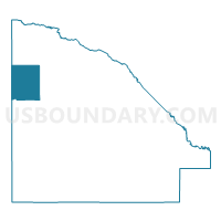
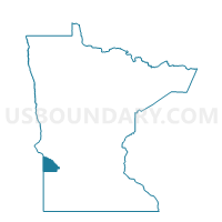
Walter Twp. Voting District, Lac qui Parle County, Minnesota
About
Outline

Summary
| Unique Area Identifier | 602835 |
| Name | Walter Twp. Voting District |
| County | Lac qui Parle County |
| State | Minnesota |
| Area (square miles) | 28.99 |
| Land Area (square miles) | 28.99 |
| Water Area (square miles) | 0.00 |
| % of Land Area | 100.00 |
| % of Water Area | 0.00 |
| Latitude of the Internal Point | 45.11004450 |
| Longtitude of the Internal Point | -96.40259730 |
Maps

Graphs
Select a template below for downloading or customizing gragh for Walter Twp. Voting District, Lac qui Parle County, Minnesota


Neighbors
Neighoring Voting District (by Name) Neighboring Voting District on the Map
- Agassiz Twp. Voting District, Lac qui Parle County, MN
- Arena Twp. Voting District, Lac qui Parle County, MN
- Augusta Twp. Voting District, Lac qui Parle County, MN
- Nassau Voting District, Lac qui Parle County, MN
- Perry Twp. Voting District, Lac qui Parle County, MN
- VTD precinct 41, Grant County, SD
- VTD precinct 42, Grant County, SD
- Yellow Bank Twp. Voting District, Lac qui Parle County, MN
Top 10 Neighboring County Subdivision (by Population) Neighboring County Subdivision on the Map
- Alban township, Grant County, SD (580)
- Vernon township, Grant County, SD (218)
- Yellow Bank township, Lac qui Parle County, MN (159)
- Walter township, Lac qui Parle County, MN (148)
- Arena township, Lac qui Parle County, MN (122)
- Augusta township, Lac qui Parle County, MN (110)
- Agassiz township, Lac qui Parle County, MN (103)
- Perry township, Lac qui Parle County, MN (101)
- Nassau city, Lac qui Parle County, MN (72)
Top 10 Neighboring Place (by Population) Neighboring Place on the Map
Top 10 Neighboring Unified School District (by Population) Neighboring Unified School District on the Map
- Lac Qui Parle Valley School District, MN (6,541)
- Milbank School District 25-4, SD (5,743)
- Ortonville -Bellingham Public School District, MN (3,549)
- Grant-Deuel School District 25-3, SD (970)